
Hidden Beaches in Florida Nobody Knows About (And How I Found Them)
I’ll be honest — I almost didn’t go back to Florida.
After three trips where I spent my time fighting for parking at Clearwater, dodging selfie sticks at Siesta Key, and paying $45 for a beach chair I used for two hours, I was done. Or so I thought.
Then a friend of mine — she grew up in Sarasota — texted me a photo. No caption, just a picture of a nearly empty beach with water so clear you could see the shadows of fish underneath the surface. White sand, tall sea oats, zero beach umbrellas with resort logos.
“Where is this?” I shot back.
“Florida,” she said. “Stop going to the tourist spots.”
That one text completely changed how I travel the Gulf and Atlantic coasts. Over the next two years, I drove down back roads, talked to locals in bait shops, used a combination of Google Earth and a (great) app called Gaia GPS to hunt down shorelines that don’t show up on the first page of any travel blog. What I found genuinely surprised me.
So here’s what I learned — real spots, real experiences, real tips on how to find your own.
Why Florida’s Hidden Beaches Stay Hidden
Before I list anything, let me explain something that took me too long to understand.
Florida has over 1,300 miles of coastline. The tourism industry naturally funnels everyone toward about fifteen of them. The rest? Either behind state park systems that don’t advertise heavily, tucked inside wildlife preserves, accessible only by a short boat ride or kayak, or just… sitting there, known mostly by people who live nearby.
The other thing — and this sounds obvious but I missed it for years — is that a lot of Florida’s most beautiful water isn’t on the Gulf or the Atlantic. It’s in the Panhandle, along barrier islands with no hotels, and on stretches of the Big Bend coast where tourism infrastructure basically doesn’t exist.
The Beaches I’ve Actually Stood On
1. Shell Mound Beach — Cedar Key Area
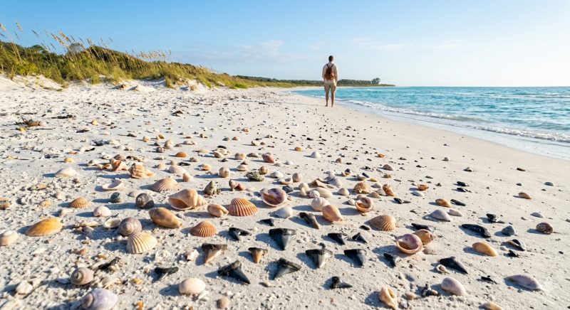
Cedar Key is already a bit under the radar, but most people who visit stick to the town. Take a kayak or a small motorboat out toward Atsena Otie Key (there’s a short paddle from the city dock, maybe 20 minutes) and you’ll find a ghost town, a small cemetery, and a beach that wraps around the island with zero other people on it most days.
I went on a Tuesday in October. There were four other people visible from where I stood, and they were on the opposite end of the island. The water is shallow and warm, tannic in parts from the tannins in nearby rivers, but clear enough to walk around in. I saw osprey, roseate spoonbills, and more shells per square foot than I’ve seen anywhere else in the state.
Practical tip: Rent a kayak from one of the outfitters on Dock Street in Cedar Key. Aim for early morning or late afternoon — the midday heat in summer is no joke. Bring bug spray; no-see-ums are vicious near the mangroves.
2. Stump Pass Beach State Park — Between Englewood and Boca Grande
This one shocked me. It’s technically a state park, it’s on the map, and yet every single time I’ve visited I’ve had long stretches of it almost entirely to myself.
The reason? It’s at the southern tip of Manasota Key, and you have to either park in a small lot (limited spaces, fills up but not insanely so) or paddle in from Lemon Bay. The beach itself faces Charlotte Harbor Pass, and the shelling here is some of the best I’ve seen on Florida’s west coast — sharks’ teeth, lightning whelks, junonia fragments.
I made the mistake of going at high noon in July once. The heat reflecting off the white sand was almost blinding, and I lasted about 90 minutes. Go in the morning. Go in fall or winter if you can.
3. Canaveral National Seashore — Apollo Beach Section
Most people associate Cape Canaveral with rocket launches, not beaches. The National Seashore that sits just north of Kennedy Space Center has 24 miles of undeveloped coastline — the longest stretch of undeveloped Atlantic coast in Florida.
Apollo Beach is the northern section, accessed from New Smyrna Beach. The drive in feels desolate in the best way — a narrow road through scrub, past lagoons, out to the ocean. The beach is wide, the waves are Atlantic-sized (better for actual swimming than the Gulf), and you can walk south for a mile or two and basically disappear.
Pro tip: Launch viewing from this beach is incredible if you time it right. SpaceX and NASA post launch schedules publicly, and Apollo Beach is a front-row seat without the crowds at the Kennedy Space Center visitor complex.
4. Lovers Key State Park — Fort Myers Beach Area
Okay, Lovers Key isn’t exactly a secret — it has a state park designation and a parking lot — but compared to Fort Myers Beach proper, it feels like another planet. The park is made up of four barrier islands, and you access the main beach via a short tram ride or a 15-minute walk.
What surprises people: the wildlife. I watched a manatee drift past in the back bay area for about ten minutes one January morning. Dolphins are almost guaranteed. The beach itself faces the Gulf and catches incredible sunsets.
The mistake I see tourists make here is staying near the main beach access and not walking north. The further north you go along the shoreline, the fewer people. Pack water, wear reef-safe sunscreen, and keep moving.
5. Fort Pickens — Pensacola Beach Area
The Panhandle is where Florida gets genuinely stunning, and Fort Pickens — located at the western tip of Santa Rosa Island — is a place that deserves way more attention than it gets.
The beach here is on the Gulf Islands National Seashore and the water color is something else. That trademark Panhandle emerald green against sugar-white sand, and on the western tip of the island, the crowds thin to almost nothing. There’s also a historic Civil War-era fort on site, which I wasn’t expecting to find interesting but spent almost two hours exploring.
Getting there requires driving through the Gulf Islands National Seashore gate (there’s a small fee, or use your National Parks pass — worth it if you visit more than one federal site a year). The road ends at the fort and the westernmost beach access. Go early, especially in summer.
How I Actually Find Hidden Beaches Now
Here’s the practical stuff, because “just explore” isn’t actually useful advice.
Google Earth is your best friend. I spend an embarrassing amount of time zooming in on Florida coastlines looking for stretches of sand without parking lots, hotels, or beach chairs visible from satellite view. If I can’t see any human infrastructure, I try to figure out how to get there.
The AllTrails and Gaia GPS apps are useful even for beach hunting, not just hiking. You can find access trails to coastal areas that aren’t obvious from a road map. Gaia in particular lets you download offline maps of areas with no cell service.
Talk to people at marinas and bait shops. This feels old-fashioned but it works. I’ve gotten four or five genuinely excellent tips from conversations I struck up with people buying live shrimp at 6am. Local knowledge is irreplaceable.
Florida State Parks website has an underused “lesser-known parks” section in their resources, and their individual park pages list every beach access point, including ones that don’t get photographed. Browse through the parks in whatever region you’re visiting and read the full descriptions.
Timing matters as much as location. Even a popular beach is manageable on a Tuesday morning in late September. If you can travel mid-week or shoulder season (late September through November, or March before spring break), the math changes dramatically.
Mistakes I Made So You Don’t Have To
Underestimating the heat. I once planned a 4-mile round-trip beach walk in Canaveral National Seashore starting at 11am in August. By the time I turned around I was genuinely struggling. Start early, always.
Not checking beach access rules. Some of the most beautiful stretches of Florida coastline are adjacent to private property or restricted wildlife nesting areas (especially during sea turtle season, March through October). Before you set up camp somewhere remote, check whether it’s part of a designated protected area with seasonal closures.
Going without bug spray near mangroves or inlets. Specifically, no-see-um repellent. Regular DEET doesn’t do much against them. Avon Skin So Soft is what the locals swear by, and honestly, it works better than anything with DEET I’ve tried for those tiny terrors.
Assuming “no crowd” means “safe water.” Remote beaches often don’t have lifeguards and may have stronger currents, rip tides, or submerged obstacles. Know your swim ability and check local tide/current conditions. The NOAA Tides and Currents website is free and actually useful.
Conculsion
The best beach I’ve found in Florida isn’t a place I’m going to name here. Not because I’m being precious about it, but because a friend told me about it in a conversation that I think was meant to stay between us — and part of what makes it special is that the people who know about it tend to protect it quietly.
What I’ll say is this: it’s on the Gulf side, it’s accessible only by a water trail, and I’ve been there four times. Never seen more than eight other people.
That beach exists for you too. You just have to be willing to take the back road, ask the guy at the bait shop, and show up before the sun gets too high FloridaTravel.
Florida has more coast than most people will ever see. The crowds are only at the edges.
Last updated by 2026
Pingback: 10 Small Towns in America That Look Unreal - cnbtub.com
Pingback: Cheapest Vacation Spots in the USA - cnbtub.com